MACHAME ROUTE
DURATION: 7 DAYS
The southern-based Machame route also referred to as the “Whiskey route”, is currently the most popular trail for those looking for a challenge. The route itself is scenically very attractive and, can throughout, physically quite challenging, especially the parts which entail a bit of climbing as well as the ascent of the Great Barranco Wall. Accommodation on the Machame route offers strictly tents only. The Machame route is normally completed in a minimum of 6 days. To increase the chance in reaching the peak, an optional acclimatization day at Barranco camp or Karanga valley is recommended. The main factors that differentiate the Machame route with the other routes is the diversity of flora and fauna as well as the walking trails. The Machame route also takes you high to Lava Tower (4630m) on the day 3 and brings you down by nearly 700m for an overnight at Barranco Camp (3860m). This is the secret to successful acclimatization.
Day 1
Machame gate (1800m) – Machame Camp (3000m)
Hiking time: 7 hours
Distance: About 18 km
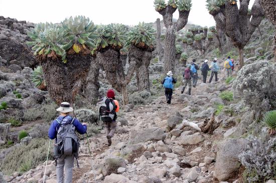
Habitat: Mountain forest
The drive from Moshi to the Mount Kilimanjaro National Park Gate takes about 50 minutes. The journey passes through the village of Machame, which is located on the lower slopes of the mountain. Once we reach the park gate, climbers are requested to make their final preparations for the climb. Porters will be seen arranging their packs containing the food, water, firewood, and other equipment. Make sure that you have all your daypack items with you as the porters travel very quickly. The guides will be pleased to assist with any additional information. We now leave the park gate and walk through the rain forest on a winding trail to the first camp, which is located at an altitude of 3,048 meters. Lower down, the trail can be muddy and slippery. Gaiters and trekking poles are essential here. We continue a short distance until we reach the Machame Hut. Here we make camp, rest, enjoy our dinner, and overnight. You have now reached an altitude of 3,000 meters.
Day 2:
Machame Camp (3000m) – Shira Camp (3840m)
Hiking time: 6 hours
Distance: About 9 km
Habitat: Moorland
Although considered to be the easiest day on the Machame Route, today’s trek includes several uphill sections. Carry plenty of drinking water, as the exposed hike can be hot on a clear day. There are several viewpoints from which you can see the plains and forests below and Kibo and Mawenzi peaks above.
As you gain altitude, notice the change in vegetation. The trees diminish in size, giving way to Kilimanjaro’s famous high altitude plants, Scenecio kilimanjari and Lobelia deckeni. After eating lunch, climb the Shira Plateau, created when Kibo’s lava flows filled the Shira crater. Continue to Shira Camp, where you will relax for the rest of the day. Kibo lies to the west and Mount Meru to the east.
Day 3:
Shira (3840m) – Lava Tower (4630m)-Barranco Camp (3860)
Hiking time: 7 hours
Habitat: Semi desert
Distance: 10 km
Although this up and down day ends with an elevation gain of only 110 meters, by early afternoon you will have climbed 690 meters to a height of 4,530 meters before beginning your descent to Barranco Camp. This day is crucial for acclimatization.
After breakfast, hike east on the Shira Plateau before reaching the junction for the Shira and Lemosho Routes. Continue on through the barren landscape before stopping for lunch. Shortly after lunch, reach the highest point of the day before descending quickly to Barranco Camp. Faster hikers can take a detour via Lava Tower, a 300-foot lava formation jutting out of the mountainside.
Barranco Camp, set among stands of Senecio Kilimanjaro, is considered to be the most scenic campsite on the Machame Route.
Day 4:
Karanga Valley (4200m)
Hiking time: 6 hours
Habitat: Alpine Desert
On the eastern side of the valley, across the stream is the Barranco Wall – a 950 ft. barrier of volcanic rock. Although it is tall and looks steep, it is very easy to climb. This is our first challenge of the day. The views from the wall are nothing less than magnificent. The rest of the day is spent skirting the base of Kibo peak over our left shoulder. We descend down into the Karanga Valley, where we rest up for the night before the tough climb up to Barafu hut.
Day 5:
Karanga Valley (4200m) – Barafu (4600m)
Hiking time: 4 hours
Habitat: Alpine Desert
Distance: 6 km
After breakfast, we leave Karanga Valley (4200m) We continue to the Barafu Hut, which is located at an altitude of 4,600 meters. You have completed the South Circuit, which offers views of the summit from many different angles. Here we make camp, rest, enjoy dinner, and prepare for the summit day. The two peaks of Mawenzi and Kibo are to be seen from this position. This section can also be divided into 2 separate days, where an in between camp will be made in or near the Karanga valley. This makes the summit day a lot easier…
Day 6:
Barafu Camp (4600m) – Uhuru Peak (5895m) – Mweka Camp (3100m)
Hiking time: 8hrs to reach Uhuru Peak
Habitat: Stone scream and ice-capped summit
Distance: 18 km
Around midnight, begin the final ascent to Uhuru Peak, the highest point in Africa. For the next six hours, hike by the light of your headlamp. The ascent to the crater rim is the most challenging part of the entire trek. The trail is very steep until you reach the crater rim at Stella Point.
The hike from Stella Point to Uhuru Peak is a gradual climb and, as far as hikes go, not very difficult. The altitude, however, makes the hike long and tiring. The crater rim hike takes approximately one hour. Upon reaching Uhuru, take photos of your guide and group at the peak before beginning the descent to Mweka Camp. On the way down from Uhuru, enjoy views of the mountain, crater, clouds and glaciers.
At Barafu Camp, eat breakfast and take a short break. You still have another three to five hours to go before reaching Mweka Camp.
Day 7:
Mweka camp (3100m) – Mweka gate (1800m)
Hiking time: about 7hrs
Habitat: Forest
Distance: 10km
After breakfast, we continue the descent down to the Mweka Park Gate. At lower elevations, it can be wet and muddy. Gaiters and trekking poles will help. Shorts and t-shirts will probably be plenty to wear (keep raingear and warmer clothing handy). A vehicle will meet you at Mweka village to drive you back to hotel in Moshi. It is time for celebrations!!